The Clarence River / Waiau Toa
New Zealand's newest geology, seen from the water
Te Waiau Toa
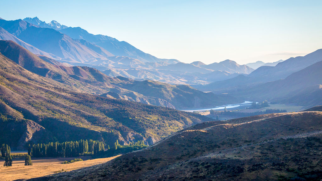
The Clarence River — Waiau Toa in te reo Māori, "the male river of swirling currents" — runs 230 kilometres from the Spenser Mountains to the Pacific Ocean just north of Kaikōura. It is a braided alpine river: a wide gravel bed carrying channels that split, rejoin and shift with every flood.
Its colour is the first thing most people notice. That turquoise comes from glacial flour — rock ground to a fine powder by mountain streams — suspended in cold, clean water and scattering the light. The second thing they notice is the country it runs through: the Inland and Seaward Kaikōura ranges rising past 2,600 metres on either side, high-country stations, and almost nobody else.
The 2016 Kaikōura earthquake
At two minutes past midnight on 14 November 2016, a magnitude 7.8 earthquake tore through this valley. At least 21 separate faults ruptured at once — one of the most complex earthquakes ever recorded. The ground moved up to 12 metres sideways and lifted as much as 10 metres. More than 100,000 landslides came down, some briefly damming the river itself.
Most geology you look at is millions of years old. Here, a good deal of it is less than ten.
What you'll see from the raft
You don't need a geology degree — the landscape does the explaining, and our guides fill in the rest as you drift.
 Fault scarps
Steps in the ground where the earth split open and one side rose above the other. Some can be traced for kilometres across the valley.
 Uplifted river terraces
Old riverbeds stacked in levels above you — and brand new ones, lifted clear of the water in a matter of seconds in 2016.
 Landslide scars
Raw slips still showing on the hillsides. One of them dammed the river at the entrance to the Sawtooth gorge; the rapid left behind is an easy Grade II.
 Greywacke & mudstone
Striped walls of hard grey sandstone banded with black mudstone — each layer an underwater landslide, laid down 65 to 150 million years ago.
 The Kaikōura ranges
Manakau, Te Ao Whekere and Tarahaka to the south; Tapuae-O-Uenuku, the highest peak north of Aoraki, dominating the northern skyline.
 Braided channels
A riverbed that redraws itself every season, wide open to the sky, with mountains on every horizon.
Our stretch of the river
We operate on roughly 190 kilometres of the Waiau Toa, through some of the most varied country the river passes. It is graded Grade II — enough moving water to be genuinely exciting, gentle enough that most of our guests have never held a paddle before.
That grading is why this river suits families so well. You get the wilderness, the scenery and the whitewater without the intimidation, and there's time between rapids to look up and take it all in. Our half day trip runs the lower river near the coast; the multi-day expeditions take you deep into the gorges and high-country stations where the only road out is the river.
Birds and wildlife
Braided rivers grow their own specialists — birds that nest in barely visible scrapes in the gravel, and depend on trapping programmes on both banks to get their chicks away.

Kārearea
New Zealand falcon, one of the world's fastest birds, hunting the open flats

Pūtangitangi
Paradise shelduck — common, noisy, and unmistakable in pairs

Tarapiroe
Black-fronted tern, nationally endangered, nesting on the gravel Oct–Jan

Kawau pū
Black shag, nesting on the cliff faces through the gorges

Tuna
Longfin eel — can live past 60 years and grow beyond a metre
Please give nesting birds room
Between October and January, terns, dotterels and oystercatchers are nesting on open gravel where the eggs are almost impossible to see. Stick to the water and to established camp sites, and keep clear of flocked-up birds on the banks.
An old travelling route
Long before it carried rafts, this valley was a route. Ngāi Tahu and, before them, Ngāti Māmoe and Waitaha used the headwaters as a pass between the east and west coasts of Te Waipounamu, carrying pounamu. The river was famous for mahinga kai — tuna, weka, kererū and, high in the Seaward Kaikōuras, the tītī that give the Clarence Reserve its name: Ka Whata Tu o Rakihouia, the feeding grounds of Rakihouia.
The English name arrived in 1839, after King William IV, Duke of Clarence before he took the throne. Both names are still in use, and both are on our sign.
Seasons and river conditions
Spring — Sep to Nov
Flow: High, fed by snowmelt
Water: 8–12°C
Character: Fast, powerful and exciting
Note: Minimum ages may rise with the flow
Summer — Dec to Feb
Flow: Moderate and settled
Water: 12–16°C
Character: The sweet spot
Note: Best of the year for families and first-timers
Autumn — Mar to May
Flow: Lower, water at its clearest
Water: 10–14°C
Character: Gentle and very scenic
Note: Stable weather — the photographers' season
Winter — Jun to Aug
Flow: Variable, rain dependent
Water: 6–10°C
Character: Cold and dramatic
Note: Snow to the valley floor; limited availability
River levels change quickly. We check flows before every trip and will always talk you through what the river is doing on the day.
Want the whole story?
The river runs a long way, and there is a lot more to it than one page can hold

The Waiau Toa in depth
A traveller's guide from the Acheron confluence to the sea — the names and legends, the high-country stations, the geology, the wildlife, and a section-by-section run through the whole river.
Read the full guide →
Grading and safety
What Grade II actually means, how we run our trips, the gear you'll be given and what we need from you on the water.
How we keep you safe →
Finding us
Our base sits on State Highway 1 at the Clarence river mouth — 30 minutes north of Kaikōura, an hour south of Blenheim.
Getting here →Come and see it for yourself
Family friendly Grade II rafting through New Zealand's freshest landscape